Hello from Washington!
I am long overdue on updating this blog and in order to catch up before I finish the trail (likely around the end of this month!) I will be posting the top photos from each week on trail along with captions. Thank you to my trail friend Lilo sharing her blog format! She’s been carrying the extra weight of a digital camera and taking amazing photos of her journey along the trail, which can be found on her blog here. I’d like to also thank e veryone who’s donated to the fundraiser, we’ve exceeded our original goal by almost $1000! My company Spectrum Forensics has generously offered to match any donations made through October 1st, so both the Max Fund and SMILE Camp will be receiving over a dollar for each mile of the trail. It’s been such a spectacular journey this summer; seeing some of the best of the west’s natural beauty, hiking thousands of miles, and making lots of friends along the way! I hope these pictures can help convey some of my experiences to all of you who have followed my journey from home. And I hope you all got outside this summer too!
Hike Good!
Cleopatra


Day 22-28: mile 369.3-529.4
Wrightwood to Hikertown/LA aquaduct
-
- A tree near the summit of Baden Powell that is, according to locals of Wrightwood, over 1000 years old.
- At the summit of Baden Powell, named for the founder of the Boy Scouts of America. There are at least 30 switchbacks on the way up, but I lost count after reaching the snow below the peak where it was just easier to go straight up.
- Marine layer in the LA valley from above.
- The desert has been full of flowers! A cluster of Christmas Tree plants makes the sandy desert floor look even more alien.
- A flowering yucca plant towering over 14 ft above the trail
- A crow overlooking the valley from a yucca blossom.
- Part of the Vasquez Rocks formation outside of Auga Dulce. Vasquez Rocks has been used as a desert movie set for numerous films including Blazing Saddles, Rat Race, and Planet of the Apes.
- Sunset over the valley before reaching Hikertown, the last stop before crossing the LA aqueduct.
- Water pipe that hikers walk along to reach the LA aqueduct. I crossed this section at night during a heat wave where the daytime temperatures reached over 100 F.


Day 29-35: mile 529.4-703.4
Hikertown/LA aqueduct-Kennedy Meadows South
-
- Week 5 began with finishing up the LA aqueduct and walking through exposed desert wind farms during a heatwave. Due to the late night start time of the aqueduct crossing, I ended up hiking around 40 miles from Hikertown into Tehachapi in less than 24 hours.
- Finding and making shade under Joshua Trees in the Mojave desert during a mid morning siesta.
- Hikers helping volunteers restock a water cache in the Mojave. Without these caches, some of my water carries would have been over 30 miles long in the desert heat.
- Juliet, Milkshake, Trail Angel Whitney, and myself at the top of Walker Pass. I met Whitney at the post office in town and she really went above and beyond helping us resupply in the town of Lake Isabella. Whitney drove us all over the spread out town and opened her home to us so we could organize our resupplies and take showers. She was even late to her soccer game so she could drop us back off at the pass over 45 min out of town. The generosity of trail angels is astounding and has shown me that there are always people out there willing to help!
- Sunset after leaving Walker Pass. I managed to hike over 26 miles while also resupplying in Lake Isabella that day! Night hiking in the desert makes for cooler miles.
- Toad on the trail while night hiking.
- Made it to mile 700! This is right before Kennedy Meadows South, the unofficial but highly celebrated end of the desert and beginning of the Sierras. Hikers are clapped in by their friends and peers as they approach the deck of the Kennedy Meadows General store.


Day 36-42: mile 703.4-789.7
Kennedy Meadows South-Independence
-
- Weighing the pack at Kennedy Meadows South before entering the Sierras. Hikers start carrying their bear can hear because it is required in the National Parks. My pack weighed in at just under 30 lbs with 2 L of water and what I thought was 5 days worth of food. I quickly learned that you need way more calories in the Sierras than in the Desert and started carrying even more food after feeling like I was starving for most of my first week!
- My cowboy camping set up on the second night in the Sierras. There was a great sunset and tantalizing views of the peaks I would be reaching in the next couple of days.
- Looking up towards the peaks near Mt. Whitney from Lower Crabtree Meadow. I had joined a group of Swiss hikers named Chef, Lilo, and PacMan when entered I entered the Sierras and there was a sense of excitement and anticipation in the group leading up to Whitney. We ascended early the next morning, enjoying the slow build of colors along the ridges and peaks, breathing in the crisp sky air above 14,000ft. Photos 4-8 are all from the next days ascent of Mt. Whitney that began at Lower Crabtree Meadow around 3:30 am.
- Hiker’s headlamps heading up Mt. Whitney under the dawn stars. Taken from the shores of Timberline Lake. 4:18 am.
- Guitar Lake from above. 6:14 am.
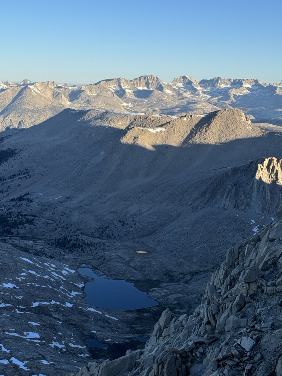
- Views down into the east valley from the ridge leading up to the summit. 6:23 am.
- Made the summit at 7:00 am on the dot with PacMan! We were shortly joined by Lilo and Chef and enjoyed an amazingly calm and comfortable hour and a half at the summit. Added bonus: there’s just enough cell service to place a call home to let everyone know where you are! We were even up their early enough that all of my friends were able to place calls back home to Switzerland and catch their loved ones before dinner.
- The crew at the summit. Photo credit to Lilo.
- Wood knot that reminds me of the swirls of Jupiter on an old tree in Sequoia National Park.
- Looking up from the snow feild on the north side of Forester Pass. Forester Pass is the official high point of the PCT even though Mt. Whitney is taller because Whitney is considered an optional blue blaze (alternate route) while Forester is on the red blaze (main/official route).
- View from the top of Kearsarge Pass which serves as the blue blaze down to a trailhead outside of the resupply town of Independence. The towns along the Sierra portion of the PCT are mainly accessible via relatively long and often steep side trails, but also offer a chance to see even more of the grandeur. This was one of my favorite panoramas in the Sierras.